")
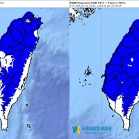
TAIPEI (Taiwan News) — Heavy cloud cover in northern and central Taiwan has led to intermittent rain, with temperatures expected to plunge by Tuesday (Jan. 23), according to meteorologist Daniel Wu (吳德榮).
Wu said a slow-moving cold wave is gradually making its way southward, lowering temperatures and bringing rain to northern and eastern areas. On Sunday (Jan. 21), temperatures will hover between 11-16 C in the north, 12-21 C in central areas, 14-24 C in the south, and 13-23 C in the east, per UDN.
On Monday (Jan. 22), coastal areas could see a low of 7 C. Plains areas could see temperatures reach as low as 5 C by Thursday (Jan. 25).
From Monday (Jan. 22) to Tuesday (Jan. 23), a second wave of moisture will bring rainfall from central to northern and eastern areas. The cold wave will gradually weaken from Thursday (Jan. 25) to Saturday (Jan. 27), Wu said.
Mountains above 1,000 meters in the north, such as Taipingshan, Lalashan, Hehuanshan, and Mount Datun, could experience snow. Yangmingshan (607 meters) is not high enough, though there is a chance of sleet.